Himachal, nestled in the Himalayas in North India, the world's mightiest mountain ranges, Himachal is called Abode of Snow; the state is surrounded by Jammu & Kashmir, Punjab, Haryana, Uttar Pradesh, Uttaranchal and the Chinese territory of Tibet.
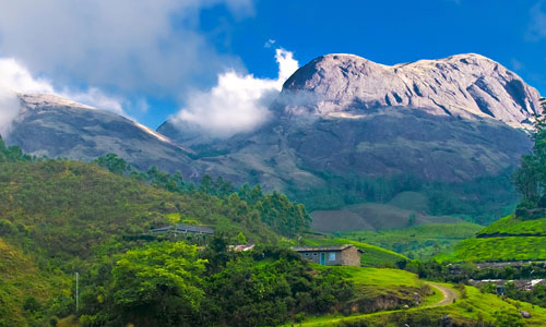
This beautiful state is blessed with some of the most picturesque and amazing landscape anywhere, it is tourist’s paradise- high snow peaks of great Himalaya, lush green valleys, deep gorges, fast flowing rivers, misty woods, enchanting lakes and flower filled meadows. Its high mountains and valleys are connected by winding roads and high altitude passes. While the splendid valleys of Kullu and Kangra are a riot of colours, in marked contrast the stark and barren terrains of Lahaul-and-Spiti at altitude of 6500m. Lahaul and Spiti have stunning lunar and scape like beauty. For centuries, the place has been called 'Devabhoomi' means Abode of God.
When it comes to the religious and spiritual places sites, surprisingly almost mountains have a highly revered and beautiful temple. Most of the temples are built in 'Shikhara' mode or Indian Dravidian architectural pattern. On the other side, the Buddhist monasteries are built in pagoda style of architecture. Chamunda Devi Temple of Chamba, Naina Devi Temple in Nainital, and Shitla Mandir of Jangla are most popular Hindu pilgrim in this region. Shimla, the state capital of Himachal once summer capital during British rule. Kullu-Manali are neighbouring hill stations surrounded by pine covered hills and lush meadows. The state is also blessed with wildlife places, offers 32 sanctuaries, 2 National Parks and 3 Games Reserves. Here one can spot a number of species of the rarest of animals and birds. There are 3 beautiful rivers originated from glacier of Himalaya the main rivers are Sutlej, Beas, Ravi, and Parbati.
Here, the local people lead a simple and calm life, tending their orchards, fields and flocks. Keeping alive their rich art and culture. They remain interested in the annual rounds of fairs and festivals, full of music, song and dance. There are also great opportunities for trekking, mountaineering, fishing, river rafting, skiing and paragliding. Recent history of Himachal takes us to post independence era when 30 princely states were united to form Himachal Pradesh. Later in 1966, when Punjab was partitioned into Punjab and Haryana, some parts of Punjab were merged with Himachal Pradesh. The state as it is known today came into being in 1971, when it became the 18th state of the Indian Union. The state lies in the north of India and is bordered by Jammu & Kashmir on North, Punjab on West & South West, Haryana on South, Uttar Pradesh on South-east and China on the East.
Shimla is popularly known as "Queen of Hill Stations." Situated in the north-West Himalayas, Shimla the summer capital of India before independence is now the capital of Himachal Pradesh. Shimla derives its name from "Shyamala"; the goddess Kali, whose temple existed in the dense forest that covered Jakhu Hill in the early 19th century. The name Shimla is derived from the Himalayan Goddess Shamla a synonym of Kali. The English named it Simla. Shimla is Covering the area of 18 sq. km. at a height of 7,238 ft. Shimla is surrounded by pine, deodar, oak and rhododendron forests. It’s well developed facilities, easy accessibility and numerous attractions make it one of Indian's most popular and biggest hill-stations.
During the monsoon, we see some of the best sunsets in the world. Surrounded by spectacular mountains and gorgeous valleys, Tourists can visit the Christ Church, the snow-covered Himalayas of Jakhu hills, Shimla State Museum and the township of Summer Hill. There's also an option to drive down to other close by destinations of Chail, Kufri, Naldhera and Mashobra.
Area: 18 sq. km., Altitude: 2,213 meters, Climate: (deg C)--Summer- Max.27, Min.14.5, Winter- Max.16.5, Min.5.2, Clothing: Summer - Light woollens, winter - Heavy woolens, Best Season: April to Mid-July, Mid-September to Mid-November, Languages spoken: Pahari (Local Dialect), Hindi, English.
Jakhoo Hill, Glen, Summer Hill, Chadwick Falls, Zoo, Navbahar, Sanket Mochen, Tara Devi Temple, Institute of Advance Studies, Aviary at Old Raj Bhavan, Tibetan Monastery, Dhengu Mata Temple.
Naldhera- 23 kms, Tattapani- 43 kms, Wildflower Hall-13 kms, Mashobra- 13 kms, Craignano-16 kms, Fruit Research Station- 08 kms, Kufri- 16 kms, Indira Holiday Home- 18 kms, Chail- 43 kms, Barog- 55 kms, Kasauli– 77 kms, Kiarighat - 23 kms, Solan- 48 kms, Bon Monastery Uohghat- 61 kms, Fagu - 22 kms, Narkanda- 64 kms, Kotgarh- 82 kms.
By Air: Nearest airport is Kullu- 23 kms. By Rail: Nearest railhead is Kalka- 90 kms. By Road: Chandigarh- 117 kms, Kullu- 220 kms, Manali- 260 kms, Delhi- 343 kms, Pathankot- 380 kms, Ambala- 151 kms, Chail- 43 kms, Dehradun- 240 kms etc.
Located in the heart of Kullu Valley in the Himachal Pradesh, Manali is one of the most beautiful hill stations of the country. The town provides ample opportunities for adventure sport and winter sports.
Once known as “Dana Agha”, Manali was an old village, the signs of that period is even today present across the town. Manali derives its name from Manu Rishi, who lived here and wrote the first constitution of India called “Manu Samriti”. In olden days, the present town of Manali was the transaction point between the traders of Hoshiarpur and Kangra and also the traders of Yarkand, Smarkand, Tash Kand, Ladakh, Zanskar and Western Tibet.
Manali is blessed with several gifts like a beautiful landscape, dense thick pine and deodar forests, ice-capped peaks, steep cliffs, rolling valleys, adventure and mystery and lush meadows of wild flowers and fragrant fruit orchard in full bloom. Besides, the Beas River with clear water meanders through the town, making Manali truly a paradise on earth for any traveller. Manali offers various sites nearby that can be visited easily on a daylong trip. The region around Manali also has some of the major passes of the country. The Rohtang Pass, Keylong, Naggar, Manikaran, Udaipur, Bhutta Weavers Colony, Kullu and the Bhuntar are some of the places that are worth a visit.
Area: 3 sq. km Altitude: 1926 Metres, above sea level Climate: (deg C)-Summer- Max. 25, Min. 12. Winter- Max. 14.5, Min. 2, Clothing: Summer- Light woollens for both the places, Winter- Heavy woollens for both the places, Best season: April to Mid-July and Sep. to Nov. Languages spoken: Hindi, Himachali, English
Raghunathji Temple, Vaishno Devi Temple, Jagannath Temple Bijli Mahadev Shrine, Vashisht Bath , Hadimba Devi Temple, Tibetan Monastery, Arjun Gumpha, Nehru Kund, Jagatsukh.
Raison- 16 kms, Katrain- 20 kms, Naggar- 28 kms, Bajaura- 15 kms, Kasol - 42 kms, Manikaran- 45 kms, Banjar- 58 kms, Larji- 34 kms, Malana, Pulga & Khirganga- 16 kms & 26 kms, Danawar Wildlife Sanctuary (near Manikaran), Khokhan Wildlife Sanctuary- 20 kms from Bhuntar, Khaiv Sanctuary- 15 kms, Tirthan Sanctuary -10 kms from Bunder Gushanini, Kothi- 12 kms & Rahla Falls- 14 kms, Solang Valley- 13 km, Rohtang Pass- 51 kms, Keylong Pass- 117 kms, Manali Wildlife Sanctuary.
By Air: Nearest airport is Bhuntar - 50 kms. By Rail: Nearest railhead is Chandigarh- 397 kms. By Road: Distance from Manali: Rohtang Pass: 51 kms, Keylong 115 kms, Leh 475 kms, Manikaran 85 kms, Delhi 570 kms, Kasauli: 275 kms, Dalhousie 385 kms, etc.
At an altitude of 2036 meter this hill station is named after the British Governor General Lord Delhousie. Dalhousie, offering spectacular views, this hill station really takes one away from the noise of the metros and towns. This summer retreat offers gateway to Chamba hills, where tourists can also enjoy visiting Kalatop-Khajjiar Trail, Punjpula, Palace, and Chamera Dam trail. Few kms away from Dalhousie is a scenic picnic spot- Khajjiar, 23 kms from Dalhousie by road and 13 kms from Kalatop is the mini Switzerland of India i.e. Khajjiar, at a height of 6400 ft. Hutchison writes, "Khajjiar is a forest glade of great beauty, 6400 feet above sea level".
Dalhousie has charming colonial architecture, including some beautiful churches. The spectacular snow-covered Dhauladhar Mountains are also visible from this enchanting town. This town of varying altitude rich in colonial look has many old churches and buildings reminding the tourist of past. St John's at Gandhi Chowk, St. Francis at Subhash Chowk, St Andrews and St Patricks at Balun are the four beautiful churches in Dalhousie. There are many big trees inside the town the view of valleys and snow capped mountains gives a spectacular look.
Area: 13 sq. km. Altitude: 2036 meters, Climate: (deg C)-Summer - Max 23.5, Min 15.5, Winter - Max 10, Min 1, Clothing: Summer - Light woollens, Winter - Heavy woolens, Best season: April to November, Languages spoken: Pahari, Hindi, English.
Panjpulla, Subhash Baoli & Jandri Ghat, The Round, Dainkund, Khajjiar, Kalatop Wild Life Sanctuary.
Kugti Wild Life Sanctuary- 35 kms, Tundah Wild Life Sanctuary- 45 kms.
By Air: Nearest airport is Amritsar- 118 kms & Jammu- 188 kms. By Rail: Nearest railhead is Pathankot- 80 kms. By Road: Amritsar- 188 kms, Jalandhar- 192 kms, Pathankot- 80 kms, Chamba- 56 kms, Manali- 402 kms, Delhi- 563 kms, Chandigarh- 352 kms, Dharamshala- 143 kms, Khajjiar- 27 kms, Jammu-188 kms.
Chamba in Himachal lies in the bosom of the Himalayas between the mighty Zanskar and Dhauladhar ranges; the Chamba valley is one of the most popular destinations in India. Chamba is situated at an altitude of 926 metres. And spreads in the area of 24 km. Located on the banks of the Ravi River the township resembles an Italian village fortress. Chamba, the valley of milk and honey is known for its streams, meadows, temples, paintings, rumal (handkerchief) and lakes. Chamba has few rivals for its scenic beauty. The ancient Pahari capital was founded in 920 A.D. by Raja Sahil Verma, who named it after his favourite daughter Champavati. Chamba's temples are mostly dedicated to Lord Shiva and Vishnu and are built of richly engraved stone. The town is also the base for Gaddi shepherds who, though nomadic in their way of life, return to Chamba periodically to stock supplies.
Chamba valley is noted for the magnificence of it's scenery-touching the fringe of the Shivaliks and having three well-defined snowy ranges, the Dauladhar, constituting the outer Himalayas, the Pir Panjal or the mid Himalayas, and the Zanskar range or the inner Himalayas. Chamba is so sheltered by snow-clad mountain barriers that its monuments escaped destruction at the hands of invaders, which is why it still remains one of the best preserved heartlands of the Himalayan arts. Chamba houses some most beautiful hill stations like Dalhousie, Khajjiar, Bharmour, Banikhet, Kala tope, Manimahesh, Triund etc. Hill station Dalhousie and Khajjiar are most south after destinations among the Indian and overseas tourists.
Area: 2.4 sq. km., Altitude: 926 meters, Climate: (deg C)-Summer- Max. 39, Min. 8, Winter- Max. 10, Min. 1.1, Clothing: Summer- Light woollens, Winter- Heavy woollens, Best Season: April to Mid July and Mid September to December, Languages Spoken: Pahari (Local Dialect), Hindi, English.
Lakshman Narayan Temple, Chamunda Temple, Katasan Devi Temple, Bhuj Sing Museum, Chaugan.
Chirmaya Topovan- 10 kms, Dal Lake- 11 kms, Dharamkot- 11 kms, Triund -17 kms, Kareri- 22 kms, Kangra- 18 kms, Jwalamukhi- 56 kms, Nadaun- 10 kms, Chintpurni- 80 kms, Masroor- 40 kms, Trilokpur- 41 kms, Nurpur- 66 kms, Sujanpur Tira- 80 kms, Chamunda Devi Temple- 15 kms, Palampur- 35 kms, Pong Wild life Sanctuary.
By Air: Nearest airport is Amritsar -200 kms. By Rail: Pathankot -90 kms is connected to major cities in India. By Road: Chandigarh- 239 kms, Delhi- 514 kms, Dalhousie- 143 kms, Jammu-197 kms, Kangra- 18 kms, Kullu- 214 kms, Manali -253 kms, Palampur- 35 kms, Shimla- 322 kms.
This is a hill station lying on the spur of the Dhauladhar range about 17 kms north- east of Kangra town. It is charming town with elegant bungalows nestling in thick coniferous forests. Dharamshala is also the home of Dalai Lama, spiritual head of Buddhists. Little Lhasa is an enchanting world where spinning prayer wheels and fluttering prayer flags spread the message of peace and universal harmony.
This hill station is wooded with oak and conifer trees and snow capped mountains enfold three sides of the town while the valley stretches in front. The snowline is perhaps more easily accessible at Dharamshala than at any other hill resort and it is possible to make a day's trek to a snow-point after an early morning's start. Dharamshala is also the headquarter of the Kangra district.
Area: 28.81 sq. km., Altitude: Between 1250 meters and 1982 meters, Climate: (deg C)-Summer - Max.33, Min.22, Winter - Max.15, Min. 0, Clothing: Summer - Light woollens, Winter - Heavy woolens, Best Season: April to June and September to November, Languages Spoken: Pahari ,Hindi.
MC leodganj , Tibetan Medical & Astro Institute, Bhagsunath, St. John's Church , Kunal Pathri, War Memorial.
Chirmaya Topovan- 10 kms, Dal Lake- 11 kms, Dharamkot- 11 kms, Triund -17 kms, Kareri- 22 kms, Kangra- 18 kms, Jwalamukhi- 56 kms, Nadaun- 10 kms, Chintpurni- 80 kms, Masroor- 40 kms, Trilokpur- 41 kms, Nurpur- 66 kms, Sujanpur Tira- 80 kms, Chamunda Devi Temple- 15 kms, Palampur- 35 kms, Pong Wild life Sanctuary.
By Air: Nearest airport is Amritsar -200 kms. By Rail: Pathankot -90 kms is connected to major cities in India. By Road: Chandigarh- 239 kms, Delhi- 514 kms, Dalhousie- 143 kms, Jammu-197 kms, Kangra- 18 kms, Kullu- 214 kms, Manali -253 kms, Palampur- 35 kms, Shimla- 322 kms.
Kullu was once known as Kulanthpitha, which means the end of the habitable world. Beyond rose the forbidding heights of the Greater Himalayas, and by the banks of the shining river Beas, lay the fabled 'Silver Valley'. The 'Silver Valley' has nature's treasures that lie carelessly scattered as flowers on the high meadows. The town of Kullu has long been a centre of faith. In the 17th century, Raja Jagat Singh installed here an idol of Lord Raghunathji, which he brought from Ayodhya. As a mark of his penance, he placed the idol on his throne and it became the presiding deity of the valley.
Here is the core of an intricate web of numerous valleys - each of which is a visual delight and seems more beautiful than the other. The mountain scapes remain spectacular whether in brilliant sunshine or in the haze of the mist. The 'Silver Valley' has nature's treasures that lie carelessly scattered as flowers on the high meadows.
Area: 6.68 sq. km., Altitude: 1,219 meters, Climate: (deg C)-Summer- Max. 30.8, Min. 18.8, Winter- Max. 16.4, Min. 5.2, Rainfall: 102 cms, Clothing: Summer- Light woollens, Winter- Heavy woolens, Best Season: Mid-March to Mid-November.
By Air: Nearest airport is Bhuntar -50 kms. By Rail: Nearest railhead is Chandigarh -272 kms. By Road: Ambala -606 kms, Chandigarh -556 kms, Delhi -798 kms, Pathankot -278 kms, Shimla -240 kms, Manali -40 kms, Palampur -164 kms, Rohtang Pass -91 kms, Dharamshala -213 kms, Dalhousie -334 kms, Jogindarnagar -166 kms.
In Himachal Pradesh, human activity is dominated by rural life: 90% of the population live in small villages and make their living almost exclusively on agriculture. The "tribal belt" consisting of the districts of Kinnaur and Lahaul and Spiti is predominantly Buddhist and the language spoken language is part of the Himalayan belt tibeto-Burman.
Kinnaur is one of the most scenic but less known districts of Pradesh Located on the Indo-Tibetan border, it is surrounded by Tibet to the east, Garhwal Himalayas to the south, Spiti valley to the north and Kullu to the west. The Satluj River, which rises on the southern slopes of Kailash Parbat near Mansarovar in Tibet, flows through the Kinnaur valley.
Lahaul and Spiti are two remote Himalayan valleys of Himachal Pradesh lying on the Indo-Tibet border. Strange, exciting, primitive, these valleys are incomparable in mountain scape, in the rugged beauty of their rocky escapements and the splendor of their snow covered peaks.
At Kinnaur: Bhabha Nagar, Nichar , Sangla Valley, Poari, Recong, Kalpa, Kothi, Ribba, Moorang, Pooh, Nako, Tashigang Gompa, Tilasangh Monastery. At Spiti: As Kullu is the valley of Gods we can say Spiti is the valley of Monasteries. Monasteries like Tabo, Gulling, Dhankar and Kee are located in this valley. Sumdo, Schichiling, Attergu, Kaza, Losar, Kunzam Pass. At Lahaul: Batal, Bara Singri Glacier, Koksar, Gondhla, Tandi, Bara Lacha Pass, Udaipur, Trilokinath Temple, Suraj Tal, Sarchu, Lake Chandra Tal, and some Monasteries viz. Kardang, Shashur, Tayl, Guru Ghantal.
Kinnaur By Air: Nearest airport is Shimla is- 224 kms. By Rail: Nearest railhead is Kalka- 314 kms. By Road: Shimla- 224 kms, Rampur- 108 kms, Pooh- 94 kms, Wangtu- 34 kms, Narkanda- 160 kms, Chakrata- 248 kms, Kufri- 210 kms, Sarahan- 77 kms, Tashigang- 116 kms, Shipki La- 126 kms. Lahaul & Spiti By Air: Kullu and Shimla are the nearest two airports. By Rail: Shimla and Pathankot are nearest railheads. By Road: Kullu-158 kms, Manali-118 kms, Pathankot-436 kms, Jogindarnagar- 284 kms, Rahla-102 kms, Rohtang- 67 kms, Khoksar- 46 kms, Gondhla-18 kms, Udaipur- 48 kms.
Explore tourism in Himachal, we offer all kind of tourism services in Himachal Pradesh, providing Himachal nature tours to Himachal and other nature tourism destinations of Himachal Pradesh- India, Himachal Pradesh tour itineraries, tourist places information, multilingual tour guide to Himachal, hotels and stay in Himachal Pradesh, we also offers travel services, hotel booking in Manali, Shimla, Chamba, Dharamshala, Khajjiar in other tourist states and cites of Himachal Pradesh. For more tour options, please visit at our itineraries http://www.india-tourism.net/itineraries.htm to chalk out your tour plan or you may write us… your choice of destinations to we shall design a tour for you. Mail us your queries at: sales@india-tourism.net
Design your tour with our expertise Plan My Trip